Natanz
From Wikipedia, the free encyclopedia
Natanz
Persian: نطنز | |
|---|---|
City | |
 Shrine Complex of Abd al Samad, built in 1304 | |
 Natanz | |
| Coordinates: 33°30′26″N 51°54′49″E / 33.50722°N 51.91361°E[1] | |
| Country | Iran |
| Province | Isfahan |
| County | Natanz |
| District | Central |
| Population (2016)[2] | |
• Total | 44,551 |
| Time zone | UTC+3:30 (IRST) |
| Website | natanz.ir |
Natanz (Persian: نطنز)[a] is a city in the Central District of Natanz County, Isfahan province, Iran, serving as capital of both the county and the district.[4] It is 70 kilometres (43 mi) south-east of Kashan.
Population
Nuclear facility
The Natanz nuclear facility, located some 33 km NNW from the town (33°43′N 51°43′E / 33.717°N 51.717°E) near a major highway, is generally recognized as Iran's central facility for uranium enrichment.[7]
Geography
Location
Natanz is located 120 km northeast of Isfahan and on the main north-south highway of Iran. Its altitude is 1666 meters above sea level. The distance between Tehran and Natanz is 326 km, and it takes about 4 hours by car.[citation needed] The Karkas mountain chain (Kuh-e Karkas) (meaning mountain of vultures), at an elevation of 3,899 meters, rises above the town.[8]
Climate
The average temperature of the city is 15.5 degrees Celsius and the average annual rainfall is 195 mm.[9][10]
| Climate data for Natanz (1992-2005) | |||||||||||||
|---|---|---|---|---|---|---|---|---|---|---|---|---|---|
| Month | Jan | Feb | Mar | Apr | May | Jun | Jul | Aug | Sep | Oct | Nov | Dec | Year |
| Daily mean °C (°F) | 2.1 (35.8) |
4.4 (39.9) |
8.5 (47.3) |
15.0 (59.0) |
19.7 (67.5) |
25.4 (77.7) |
28.2 (82.8) |
27.7 (81.9) |
23.4 (74.1) |
17.0 (62.6) |
9.5 (49.1) |
4.6 (40.3) |
15.5 (59.8) |
| Average precipitation mm (inches) | 34.0 (1.34) |
23.2 (0.91) |
43.3 (1.70) |
28.6 (1.13) |
19.8 (0.78) |
2.1 (0.08) |
0.5 (0.02) |
0.9 (0.04) |
0.1 (0.00) |
5.6 (0.22) |
16.6 (0.65) |
20.6 (0.81) |
195.3 (7.68) |
| Average snowy days | 3.6 | 2.6 | 1.3 | 0 | 0 | 0 | 0 | 0 | 0 | 0 | 0.1 | 1.9 | 9.5 |
| Average relative humidity (%) | 57 | 47 | 42 | 37 | 31 | 21 | 22 | 18 | 21 | 31 | 45 | 55 | 36 |
| Average dew point °C (°F) | −5.4 (22.3) |
−6.2 (20.8) |
−4.4 (24.1) |
0.0 (32.0) |
1.8 (35.2) |
1.7 (35.1) |
4.1 (39.4) |
1.6 (34.9) |
0.0 (32.0) |
−0.7 (30.7) |
−2.5 (27.5) |
−4.0 (24.8) |
−1.2 (29.9) |
| Source: IRIMO[11][12][13][14][15] | |||||||||||||
Agriculture
Agriculture is Natanz' major industry. Local produce includes beets, walnuts, and pomegranates.[16] The city is noted for its pears[17] and its saffron, most of which is exported.[18] Natanz' climate is well-suited for saffron, and the city has produced as much as 1,600 kg of dry saffron in a year.[19]
Historical monuments
It is known as the shrine of Abd as-Samad.[17] Elements in the present complex date from 1304 with subsequent additions and restorations, such as the Khaneqah and Muqarnas vault. The tomb honors the Sufi Sheikh Abd al-Samad, and was built by the Sheikh's disciple, the Ilkhanid vizier Zain al-Din Mastari.[citation needed]
Gallery
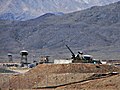 Anti-aircraft guns guarding Natanz nuclear facility
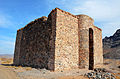 Natanz Stone Fortress
 Natanz mosque next to the old Chenar
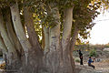 Ancient tree of Natanz
 Portal of Abd al-Samad complex


.jpg)
.jpg)
See also
![]() Media related to Natanz at Wikimedia Commons
Media related to Natanz at Wikimedia Commons
