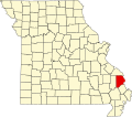
Randol Township, Cape Girardeau County, Missouri
From Wikipedia, the free encyclopedia
Randol Township | |
|---|---|
 | |
| Coordinates: 37°23′17″N 089°32′45″W / 37.38806°N 89.54583°W | |
| Country | United States |
| State | Missouri |
| County | Cape Girardeau |
| Area | |
• Total | 66.92 sq mi (173.31 km2) |
| • Land | 65.29 sq mi (169.11 km2) |
| • Water | 1.6 sq mi (4.2 km2) 2.42% |
| Elevation | 650 ft (198 m) |
| Population (2000) | |
• Total | 4,030 |
| • Density | 62/sq mi (23.8/km2) |
| FIPS code | 29-60572[2] |
| GNIS feature ID | 0766401 |
Randol Township is one of ten townships in Cape Girardeau County, Missouri, USA. As of the 2000 census, its population was 4,030.
Randol Township was founded in 1872.[3] The township derives its name from Enos Randal, a pioneer citizen.[4]
Randol Township is located on the west bank of the Mississippi River, which forms the border with Illinois. The mouth of the Ohio River at Cairo, at the intersection of the states of Missouri, Illinois, and Kentucky, is about 70 km to the southeast.[5]