Whitewater Township, Cape Girardeau County, Missouri
From Wikipedia, the free encyclopedia
Whitewater Township | |
|---|---|
 | |
| Coordinates: 37°27′10″N 089°48′16″W / 37.45278°N 89.80444°W | |
| Country | United States |
| State | Missouri |
| County | Cape Girardeau |
| Area | |
• Total | 36.50 sq mi (94.54 km2) |
| • Land | 36.45 sq mi (94.41 km2) |
| • Water | 0.050 sq mi (0.13 km2) 0.14% |
| Elevation | 443 ft (135 m) |
| Population (2000) | |
• Total | 1,263 |
| • Density | 35/sq mi (13.4/km2) |
| FIPS code | 29-79630[2] |
| GNIS feature ID | 0766404 |
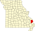
Whitewater Township is one of ten townships in Cape Girardeau County, Missouri, USA. As of the 2000 census, its population was 1,263.
Geography
Whitewater Township covers an area of 36.5 square miles (95 km2) and contains no incorporated settlements. Known cemeteries include Baker, Bollinger Family Cemetery at Bollinger Mill, Born, Caney Fork – New and Old, Estes, Ferguson, Gladish, Kurre, Kurreville/Maintz, Limbaugh, Mayfield, Miller at Millersville, Niswonger New and Old, Old Salem Methodist, Riehn, Schmidt, Snider, Wilkerson 1 and 2, Wise.
The streams of Caney Fork, Crawford Creek, Dry Creek, Little Muddy Creek, Panther Creek, Sandy Branch and Wolf Creek run through this township.