Santa Rita, Montana
From Wikipedia, the free encyclopedia
Santa Rita, Montana | |
|---|---|
  Santa Rita Location of Santa Rita, Montana  Santa Rita Santa Rita (the United States) | |
| Coordinates: 48°41′54″N 112°19′08″W / 48.69833°N 112.31889°W | |
| Country | United States |
| State | Montana |
| County | Glacier |
| Area | |
• Total | 3.46 sq mi (8.97 km2) |
| • Land | 3.46 sq mi (8.97 km2) |
| • Water | 0 sq mi (0.00 km2) |
| Elevation | 3,799 ft (1,158 m) |
| Population (2020) | |
• Total | 107 |
| • Density | 30.9/sq mi (11.93/km2) |
| Time zone | UTC-7 (Mountain (MST)) |
| • Summer (DST) | UTC-6 (MDT) |
| Area code | 406 |
| FIPS code | 30-66250 |
| GNIS feature ID | 2583843[2] |
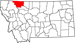
Santa Rita is a census-designated place (CDP) in Glacier County, Montana, United States. The population was 107 at the 2020 census.[3] It is located along Montana Secondary Highway 213, 5 miles north of Cut Bank.
Climate
According to the Köppen Climate Classification system, Santa Rita has a semi-arid climate, abbreviated "BSk" on climate maps.[3]