Seville Colony, Montana
From Wikipedia, the free encyclopedia
CountryUnited States
Elevation3,937 ft (1,200 m)
Seville Colony, Montana | |
|---|---|
  Seville Colony  Seville Colony | |
| Coordinates: 48°42′21″N 112°35′34″W / 48.70583°N 112.59278°W | |
| Country | United States |
| State | Montana |
| County | Glacier |
| Area | |
• Total | 0.37 sq mi (0.97 km2) |
| • Land | 0.37 sq mi (0.97 km2) |
| • Water | 0 sq mi (0.00 km2) |
| Elevation | 3,937 ft (1,200 m) |
| Population (2020) | |
• Total | 0 |
| • Density | 0/sq mi (0/km2) |
| Time zone | UTC-7 (Mountain (MST)) |
| • Summer (DST) | UTC-6 (MDT) |
| ZIP Code | 59427 (Cut Bank) |
| Area code | 406 |
| FIPS code | 30-67192 |
| GNIS feature ID | 2806627[2] |
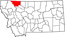
Seville Colony (Blackfeet: Tsahkiitoh, "Hill on a prairie") is a Hutterite community[3] and census-designated place (CDP) in Glacier County, Montana, United States. As of the 2020 census, Seville Colony had a population of 0.[4] It is in the eastern part of the county, 17 miles (27 km) by road northwest of Cut Bank and 26 miles (42 km) northeast of Browning.
Seville Colony was first listed as a CDP prior to the 2020 census.[2]