Sierra La Culata National Park
National Park in the Venezuelan Andes
From Wikipedia, the free encyclopedia
The Sierra La Culata National Park[1] (Spanish: Parque nacional Sierra de La Culata)[2] Also Sierra de la Culata National Park is a national park[3] of Venezuela[4] that is located in the northeastern branch of the Venezuelan Andes,[5] in the states Mérida and Trujillo. It was decreed a national park on December 7, 1989. It has a high mountain climate, with temperatures ranging between −2 and 24 °C (28 and 75 °F), and its surface area is 200,400 hectares (774 sq mi).
.jpg)
| Sierra La Culata National Park Parque nacional Sierra de La Culata | |
|---|---|
| |
.svg) Location | |
| Location | |
| Coordinates | 8°48′N 70°58′W |
| Area | 2,004 km2 (774 sq mi) |
| Established | December 7, 1989 |
The vegetation is characterized by the presence of numerous species of frailejones, shrubs such as ericaceae and melastomataceae; ferns and numerous mosses, liver lichens and fungi. The tree of the zone is the Coloradito.
This park houses species such as the Jaguar, the Spectacled bear, the Armadillo, the Loach, the Andean condor, and amphibians such as the nurse frog (sapito niñera).[clarification needed]
Within the park are at least one endemic species of brachythermal butterfly (Round empetrus[check spelling]).
Gallery
 Snow
Snow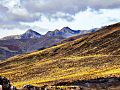 Mucubají paramo
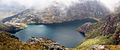 Las Iglesias Lagoon
 View of the Sierra
 Horses in the park
 La Calzona Lagoon
 El Muerto Valley
 Mifafí Valley
 Las Cascadas Valley
 Mountains in the Park


