Torboy, Washington
From Wikipedia, the free encyclopedia
Torboy, Washington | |
|---|---|
 Torboy  Torboy | |
| Coordinates: 48°40′38″N 118°40′08″W / 48.67722°N 118.66889°W[1] | |
| Country | United States |
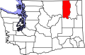
| State | Washington |
| County | Ferry |
| Area | |
• Total | 0.95 sq mi (2.47 km2) |
| • Land | 0.93 sq mi (2.40 km2) |
| • Water | 0.027 sq mi (0.07 km2) |
| Elevation | 2,389 ft (728 m) |
| Population (2010) | |
• Total | 49 |
| • Density | 53/sq mi (20.4/km2) |
| Time zone | Pacific |
| ZIP code | 99166[2] |
| Area code | 360 |
| GNIS feature ID | 2631209[1] |
Torboy is a census-designated place in Ferry County, Washington, United States. As of the 2020 census, Torboy had a population of 43.[3]