Argenta, Montana
From Wikipedia, the free encyclopedia
Country United States
 United States
Elevation6,129 ft (1,868 m)
Argenta, Montana | |
|---|---|
  Argenta  Argenta | |
| Coordinates: 45°16′43″N 112°51′38″W / 45.27861°N 112.86056°W | |
| Country | United States |
| State |  Montana Montana |
| County | Beaverhead |
| Area | |
• Total | 0.30 sq mi (0.77 km2) |
| • Land | 0.30 sq mi (0.77 km2) |
| • Water | 0 sq mi (0.00 km2) |
| Elevation | 6,129 ft (1,868 m) |
| Population (2020) | |
• Total | 35 |
| • Density | 117.5/sq mi (45.35/km2) |
| Time zone | UTC-7 (Mountain (MST)) |
| • Summer (DST) | UTC-6 (MDT) |
| ZIP Code | 59725 (Dillon) |
| Area code | 406 |
| FIPS code | 30-02350 |
| GNIS feature ID | 2804241[2] |
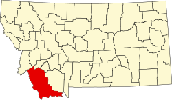
Argenta is an unincorporated community and census-designated place (CDP) in Beaverhead County, Montana, United States. It is in southwestern Montana, 13 miles (21 km) northwest of Dillon, the Beaverhead county seat. Argenta is in the valley of Rattlesnake Creek, a southeast-flowing tributary of the Beaverhead River, part of the Jefferson River watershed leading to the Missouri and finally the Mississippi River.
Argenta was first listed as a CDP prior to the 2020 census.[2] As of the 2020 census, Argenta had a population of 35.[3]