Dell, Montana
From Wikipedia, the free encyclopedia
Dell, Montana | |
|---|---|
 | |
 Dell, Montana  Dell, Montana | |
| Coordinates: 44°43′36″N 112°41′49″W / 44.72667°N 112.69694°W | |
| Country | |
| State | |
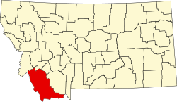
| County | Beaverhead |
| Area | |
• Total | 0.45 sq mi (1.16 km2) |
| • Land | 0.45 sq mi (1.16 km2) |
| • Water | 0 sq mi (0.00 km2) |
| Elevation | 6,004 ft (1,830 m) |
| Population (2020) | |
• Total | 17 |
| • Density | 38.0/sq mi (14.69/km2) |
| Time zone | UTC-7 (MST) |
| ZIP code | 59724[3] |
| GNIS feature ID | 2804243[2] |
Dell is a census-designated place in Beaverhead County, Montana, United States. As of the 2020 census, Dell had a population of 17.[4] The settlement is located in a valley beside the Red Rock River.
Dell was founded as a station stop on the newly completed Utah and Northern Railway, which reached Butte in 1881.[5] It became a trading center for ranchers.[6]
Dell School opened in 1903, and was later converted to a restaurant.[7][8] In 1907, the Dell Telephone Company was founded to construct and maintain a telephone system to Sheep Creek Basin.[9]
Geography
Dell is noted for having the lightest precipitation in Montana.[10]
Climate
According to the Köppen Climate Classification system, Dell has a semi-arid climate, abbreviated "BSk" on climate maps.[11]