List of extreme summits of Mexico
From Wikipedia, the free encyclopedia

This article comprises four sortable tables of mountain summits of Mexico that are higher than any other point north or south of their latitude or east or west their longitude in Mexico.
The summit of a mountain or hill may be measured in three principal ways:
- The topographic elevation of a summit measures the height of the summit above a geodetic sea level.[1]
- The topographic prominence of a summit is a measure of how high the summit rises above its surroundings.[1][2][3]
- The topographic isolation (or radius of dominance) of a summit measures how far the summit lies from its nearest point of equal elevation.[4]
| Rank | Mountain Peak | State | Mountain range | Elevation | Prominence | Isolation | Location |
|---|---|---|---|---|---|---|---|
| 4 | Cerro las Capillas[5] | Trans-Mexican Volcanic Belt | 2890 m 9,482 ft | 1590 m 5,217 ft | 55.8 km 34.7 mi |
19°33′19″N 104°08′50″W / 19.5552°N 104.1472°W | |
| 3 | La Malinche (volcano)[6][7][a][b] (Matlalcueye) |
Trans-Mexican Volcanic Belt | 4430 m 14,534 ft | 1920 m 6,299 ft | 63.9 km 39.7 mi |
19°13′52″N 98°01′56″W / 19.2310°N 98.0321°W | |
| 2 | Iztaccíhuatl[8][9][c] | Trans-Mexican Volcanic Belt | 5230 m 17,159 ft | 1560 m 5,118 ft | 17.51 km 10.88 mi |
19°10′49″N 98°38′29″W / 19.1802°N 98.6415°W | |
| 1 | Pico de Orizaba[10][11][d] (Citlaltépetl) |
Trans-Mexican Volcanic Belt | 5636 m 18,491 ft | 4922 m 16,148 ft | 2,690 km 1,672 mi |
19°01′50″N 97°16′11″W / 19.0305°N 97.2698°W |
Southernmost high summits
| Rank | Mountain Peak | State | Mountain range | Elevation | Prominence | Isolation | Location |
|---|---|---|---|---|---|---|---|
| 3 | Volcán Tacaná[12][13][e] | Sierra Madre de Chiapas | 4067 m 13,343 ft | 1037 m 3,402 ft | 24.1 km 14.99 mi |
15°07′56″N 92°06′30″W / 15.1323°N 92.1084°W | |
| 2 | Popocatépetl[14][15][f][g] | Trans-Mexican Volcanic Belt | 5410 m 17,749 ft | 3040 m 9,974 ft | 143 km 88.8 mi |
19°01′21″N 98°37′40″W / 19.0225°N 98.6278°W | |
| 1 | Pico de Orizaba[10][11][d] (Citlaltépetl) |
Trans-Mexican Volcanic Belt | 5636 m 18,491 ft | 4922 m 16,148 ft | 2,690 km 1,672 mi |
19°01′50″N 97°16′11″W / 19.0305°N 97.2698°W |
Easternmost high summits
| Rank | Mountain Peak | State | Mountain range | Elevation | Prominence | Isolation | Location |
|---|---|---|---|---|---|---|---|
| 3 | Volcán Tacaná[12][13][e] | Sierra de Istatan | 4067 m 13,343 ft | 1037 m 3,402 ft | 24.1 km 14.99 mi |
15°07′56″N 92°06′30″W / 15.1323°N 92.1084°W | |
| 2 | Cofre de Perote[16][17][h] | Trans-Mexican Volcanic Belt | 4210 m 13,812 ft | 1340 m 4,396 ft | 52.9 km 32.9 mi |
19°29′38″N 97°08′53″W / 19.4940°N 97.1480°W | |
| 1 | Pico de Orizaba[10][11][d] (Citlaltépetl) |
Trans-Mexican Volcanic Belt | 5636 m 18,491 ft | 4922 m 16,148 ft | 2,690 km 1,672 mi |
19°01′50″N 97°16′11″W / 19.0305°N 97.2698°W |
Westernmost high summits
Gallery
 The summit of Pico de Orizaba, a stratovolcano on the border between Puebla and Veracruz, is the highest peak of Mexico.
 The summit of Popocatépetl, a stratovolcano at the junction of Puebla, State of Mexico and Morelos, is the second highest peak of Mexico.
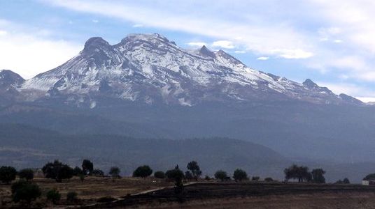 The summit of Iztaccíhuatl, a stratovolcano on the border between Puebla and State of Mexico, is the third highest peak of Mexico.
 Nevado de Toluca is a stratovolcano in State of Mexico.
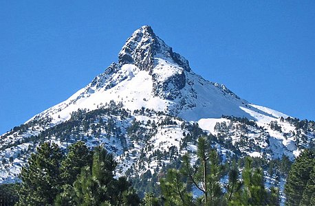 Nevado de Colima is an stratovolcano in Jalisco near the border with Colima.
 Cofre de Perote is a shield volcano in Veracruz.


See also
- List of mountain peaks of North America
- List of mountain peaks of Greenland
- List of mountain peaks of Canada
- List of mountain peaks of the Rocky Mountains
- List of mountain peaks of the United States
- List of mountain peaks of Mexico
- List of the ultra-prominent summits of Mexico
- List of extreme summits of Mexico
- List of mountain peaks of Central America
- List of mountain peaks of the Caribbean
- Mexico
- Physical geography