List of Singapore MRT stations
From Wikipedia, the free encyclopedia
The Mass Rapid Transit (MRT)[a] is a rapid transit system in Singapore and the country's principal mode of public transport.[3] Owned by the Land Transport Authority,[4] the system spans 240 kilometres (150 mi) and has six lines: the North–South Line (NSL), East–West Line (EWL), North East Line (NEL), Circle Line (CCL), Downtown Line (DTL), and Thomson–East Coast Line (TEL). The MRT has two operators: SMRT Trains and SBS Transit. SMRT operates the NSL, EWL, CCL, and TEL, whilst SBS operates the NEL and DTL.[5] Two MRT lines – the Jurong Region Line (JRL) and the Cross Island Line (CRL) – are under construction or planning. As of 2025, the MRT serves 3.49 million passengers a day.[6]

As of March 2026, there are 143 stations in operation, all of which are wheelchair accessible.[7] Some MRT stations are public civil defence shelters, which protect occupants from attacks during a wartime emergency.[8] Additionally, most NEL, CCL, DTL, and TEL stations in operation, as well as two NSL stations, have public artworks as part of the Art in Transit programme.[9] All MRT lines pass through the Central Area. With 35 stations, the EWL starts from Pasir Ris and terminates at Tuas Link, serving areas such as Tampines, Bedok, Queenstown, Clementi, and Jurong West.[10] At Tanah Merah station, the line splits into a branch service, the Changi Airport Extension (CAE); the CAE service operates from Tanah Merah to Changi Airport stations.[11] The NSL, with 27 stations, starts from Jurong East and terminates at Marina South Pier. The line goes through areas such as Choa Chu Kang, Sembawang, Yishun, and Toa Payoh. The NEL, serving 17 stations, starts from HarbourFront and terminates at Punggol Coast; the areas the line passes through outside of the Central Area include Serangoon, Hougang, Sengkang, and Punggol. The CCL serves 30 stations, and operates in an incomplete loop from Dhoby Ghaut to HarbourFront. Areas passed through by the CCL include Geylang, Serangoon, Toa Payoh, Queenstown, and Bukit Merah.[10] The line also has a branch service, the Circle Line Extension (CE), which travels from Promenade to Marina Bay; trains on this service start from HarbourFront and terminate at Marina Bay during peak hours, though during non-peak hours, trains travel from Marina Bay and Stadium as a shuttle train service.[12] The DTL starts from Bukit Panjang and terminates at Expo, serving 35 stations in areas such as Bukit Panjang, Bukit Timah, Geylang, Bedok, and Changi; the line also crosses itself in a loop in the Central Area. With 27 stations, the TEL spans from Woodlands North to Bayshore stations and pass through areas such as Woodlands, Mandai, Ang Mo Kio, and Marine Parade.[10]
There are nine standalone terminal stations, 22 interchange stations, and six stations that are both terminal and interchange stations. There are 25 stations connected to bus interchanges, whilst four stations interchange with the Light Rail Transit (LRT) system.[13] Changi Airport station offers connections to Changi Airport Terminals 2 and 3, and Marina South Pier and HarbourFront stations have connections to ferry services; HarbourFront is also connected with the Singapore Cable Car and Sentosa Express.[14] There are four non-operational stations planned to open in the future, which are Bukit Brown on the CCL as well as Marina South, Mount Pleasant, and Tagore on the TEL.[15] 42 stations are under construction; of these, Bahar Junction is the only station designated as an interchange, whilst three stations – Aviation Park, Pandan Reservoir, and Peng Kang Hill – are terminal stations. Three stations – Jurong Pier, Sungei Bedok, and West Coast – are both interchange and terminal stations. Riviera station on the CRL is expected to be connected with the station's LRT station.[16] Five stations are under planning; of these, two stations, Changi Terminal 5 and Sungei Kadut, are expected to be terminal and interchange stations, respectively. The former is also planned to be connected to Changi Airport Terminal 5.[17]
History
.svg)
Plans for a national rail transport system were conceptualised in a study by the Singapore government and United Nations Development Programme in 1971, which hypothesised that the country would need such a system by 1992. Various studies on the feasibility of a rapid transit system were conducted between 1972 to 1980, with some experts opposing the idea and arguing that Singapore's bus system should be further expanded. The government approved the MRT's construction in 1982,[18] and the first phase of the system opened on 7 November 1987 with five stations from Yio Chu Kang to Toa Payoh.[19] Between 1987 and 1988, 20 stations commenced operations, which included nine stations from Novena to Outram Park on 12 December 1987,[20] six stations from Tiong Bahru to Clementi on 12 March 1988,[21] three stations from Jurong East to Lakeside on 5 November 1988,[22] and Khatib and Yishun stations on 20 December 1988.[23] However, the MRT system was split into two lines on 28 October 1989: the North–South Line (NSL), which went from Yishun to Marina Bay, and the East–West Line (EWL), which went from Tanah Merah to Lakeside.[24] Following the split, Marina Bay station and nine stations from Bugis to Tanah Merah commenced operations on 4 November 1989.[25] On 16 December 1989, a three-station extension on the EWL from Simei to Pasir Ris opened.[26] A new line, the Branch Line, opened on 10 March 1990, and consisted of four stations from Jurong East to Choa Chu Kang.[27] With the opening of Boon Lay station on 6 July 1990, the initial MRT system was completed.[28]
Six stations on the NSL's Woodlands Extension, from Sembawang to Yew Tee, opened on 10 February 1996. The Branch Line was merged with the NSL on the same date.[29] Between 2001 to 2002, three stations on the EWL opened, including Dover as an infill station on 18 October 2001[30] and Expo and Changi Airport on the EWL's Changi Airport Extension; the latter two opened on 10 January 2001 and 8 February 2002, respectively.[31] On 20 June 2003, most of the North East Line (NEL), which consisted of 12 stations from HarbourFront to Punggol, opened;[32] two stations, Buangkok and Woodleigh, later opened as infill stations on 15 January 2006 and 20 June 2011, respectively.[33] On 28 February 2009, the EWL was extended to Joo Koon and Pioneer stations.[34] Various stages of the Circle Line (CCL) opened from 2009 to 2012, which included three stations from Marymount to Bartley on 28 May 2009,[35] nine stations from Tai Seng to Dhoby Ghaut on 17 April 2010,[36] 10 stations from Caldecott to HarbourFront on 8 October 2011,[37] and the Circle line Extension to Marina Bay on 13 January 2012, which included Bayfront station.[38] The Downtown Line (DTL) also opened in various stages between 2013 to 2017, which included two stations from Bugis to Chinatown on 22 December 2013,[39] nine stations from Bukit Panjang to Rochor on 27 December 2015,[40] and 13 stations from Fort Canning to Expo on 21 October 2017.[41] From 2014 to 2019, several new stations opened on existing lines, including the NSL extension to Marina South Pier on 23 November 2014,[42] four stations from Gul Circle to Tuas Link on the EWL on 16 June 2017,[43] and Canberra on 2 November 2019 as an infill station on the NSL.[44] From 2020 to 2024, 27 stations on the Thomson–East Coast Line (TEL) opened for services, including two stations from Woodlands North to Woodlands South on 31 January 2020,[45] five stations from Springleaf to Caldecott on 28 August 2021,[46] seven stations from Stevens to Gardens by the Bay on 13 November 2022,[47] and seven stations from Tanjong Rhu to Bayshore on 23 June 2024.[48] The NEL extended to Punggol Coast on 10 December 2024,[49] and Hume station opened on the DTL as an infill station on 28 February 2025.[50]
Six stations are expected to open in 2026.[51] In the middle of 2026, Cantonment, Keppel, and Prince Edward Road stations on the CCL are expected to start operations, and are planned to complete the CCL's loop.[52] In the second half of the year, the DTL and TEL are expected to be extended to interchange with other in Sungei Bedok; Bedok South on the TEL and Xilin on the DTL are scheduled to be open at the same time.[51] Also on the TEL, Founders' Memorial station is planned to open at the end of 2028.[53] There are two upcoming lines on the MRT: the Jurong Region Line (JRL) and Cross Island Line (CRL). 21 stations on the JRL are under construction, and are scheduled to commence operations in various stages from 2028 to 2029, which includes 14 stations in 2028 and seven stations in 2029.[52] As for the CRL, 21 stations under construction are also planned to commence operations in various stages between 2030 and 2032, including 12 stations in 2030,[54] six stations in 2032,[55] and a branch service from Pasir Ris to Punggol consisting of three stations in 2032.[56] Five stations under planning are expected to open around the mid-2030s, which are Brickland on the NSL in 2034,[57] Changi Terminal 5 on the TEL and CRL in the mid-2030s,[58] JS2A on the JRL,[52] and DE1 on the DTL and Sungei Kadut on the NSL and DTL; the last two are expected to open in 2035.[59]
MRT stations
In operation
| Station name | Station code[60][b] | Line[c] | Opened[d] | Connections[e] | Ref | ||
|---|---|---|---|---|---|---|---|
| English[13][f] | Chinese[1] | Tamil[2] | |||||
| Admiralty | 海军部 | அட்மிரல்ட்டி | NS10 | North–South Line | 10 February 1996 | [62] | |
| Aljunied | 阿裕尼 | அல்ஜூனிட் | EW9 | East–West Line | 4 November 1989 | [25] | |
| Ang Mo Kio | 宏茂桥 | அங் மோ கியோ | NS16 | North–South Line Cross Island Line (under construction) |
7 November 1987 | [63] | |
| Bartley | 巴特礼 | பார்ட்லி | CC12 |
Circle Line | 28 May 2009 | [35] | |
| Bayfront* | 海湾舫 | பேஃபிரண்ட் | CE1 DT16 | Circle Line Extension Downtown Line Circle Line (in 2026) |
13 January 2012 | [64] | |
| Bayshore‡ | 碧湾 | பேஷோர் | TE29 |
Thomson–East Coast Line | 23 June 2024 | [48] | |
| Beauty World | 美世界 | பியூட்டி வோர்ல்ட் | DT5 |
Downtown Line | 27 December 2015 | [40] | |
| Bedok | 勿洛 | பிடோக் | EW5 | East–West Line | 4 November 1989 | [65] | |
| Bedok North | 勿洛北 | பிடோக் நார்த் | DT29 |
Downtown Line | 21 October 2017 | [41] | |
| Bedok Reservoir | 勿洛蓄水池 | பிடோக் ரெசவோர் | DT30 |
||||
| Bencoolen | 明古连 | பென்கூலன் | DT21 | ||||
| Bendemeer | 明地迷亚 | பெண்டிமியர் | DT23 | ||||
| Bishan* | 碧山 | பீஷான் | NS17 CC15 |
North–South Line Circle Line |
7 November 1987 | [66] | |
| Boon Keng | 文庆 | பூன் கெங் | NE9 |
North East Line | 20 June 2003 | [32] | |
| Boon Lay | 文礼 | பூன் லே | EW27 | East–West Line Jurong Region Line (under construction) |
6 July 1990 | [67] | |
| Botanic Gardens* | 植物园 | பூ மலை | CC19 DT9 |
Circle Line Downtown Line |
8 October 2011 | [37] | |
| Braddell | 布莱德 | பிரேடல் | NS18 |
North–South Line | 7 November 1987 | [19] | |
| Bras Basah | 百胜 | பிராஸ் பாசா | CC2 | Circle Line | 17 April 2010 | [36] | |
| Bright Hill | 光明山 | பிரைட் ஹில் | TE7 |
Thomson–East Coast Line Cross Island Line (under construction) |
28 August 2021 | [46] | |
| Buangkok | 万国 | புவாங்கோக் | NE15 |
North East Line | 15 January 2006 | [68] | |
| Bugis* | 武吉士 | பூகிஸ் | EW12 DT14 |
East–West Line Downtown Line |
4 November 1989 | [25] | |
| Bukit Batok | 武吉巴督 | புக்கிட் பாத்தோக் | NS2 | Branch Line (10 March 1990 to 10 February 1996) North–South Line (Branch Line merger) |
10 March 1990 | [69] | |
| Bukit Gombak | 武吉甘柏 | புக்கிட் கோம்பாக் | NS3 | ||||
| Bukit Panjang‡ | 武吉班让 | புக்கிட் பாஞ்சாங் | BP6 – DT1 |
Downtown Line | 27 December 2015 | [70] | |
| Buona Vista* | 波那维斯达 | புவன விஸ்தா | EW21 CC22 |
East–West Line Circle Line |
12 March 1988 | [21] | |
| Caldecott* | 加利谷 | கால்டிகாட் | CC17 TE9 |
Circle Line Thomson–East Coast Line |
8 October 2011 | [37] | |
| Canberra | 坎贝拉 | கென்பரா | NS12 | North–South Line | 2 November 2019 | [44] | |
| Cashew | 凯秀 | கேஷ்யூ | DT2 |
Downtown Line | 27 December 2015 | [40] | |
| Changi Airport‡ | 樟宜机场 | சாங்கி விமானநிலையம் | CG2 | East–West Line Changi Airport Extension Thomson–East Coast Line (replacing the Changi Airport Extension) |
8 February 2002 | [71] | |
| Chinatown* | 牛车水 | சைனாடவுன் | NE4 DT19 |
North East Line Downtown Line |
20 June 2003 | [32] | |
| Chinese Garden | 裕华园 | சீனத் தோட்டம் | EW25 | East–West Line | 5 November 1988 | [22] | |
| Choa Chu Kang | 蔡厝港 | சுவா சூ காங் | NS4 BP1 | Branch Line (10 March 1990 to 10 February 1996) North–South Line (Branch Line merger) Jurong Region Line (under construction) |
10 March 1990 | [72] | |
| City Hall* | 政府大厦 | நகர மண்டபம் | NS25 EW13 |
North–South Line East–West Line |
12 December 1987 | [20] | |
| Clarke Quay | 克拉码头 | கிளார்க் கீ | NE5 |
North East Line | 20 June 2003 | [32] | |
| Clementi | 金文泰 | கிளிமெண்டி | EW23 | East–West Line Cross Island Line (under construction) |
12 March 1988 | [73] | |
| Commonwealth | 联邦 | காமன்வெல்த் | EW20 | East–West Line | |||
| Dakota | 达科达 | டகோட்டா | CC8 |
Circle Line | 17 April 2010 | [36] | |
| Dhoby Ghaut^ | 多美歌 | தோபி காட் | NS24 NE6 CC1 | North–South Line North East Line Circle Line |
12 December 1987 | [20] | |
| Dover | 杜弗 | டோவெர் | EW22 | East–West Line | 18 October 2001 | [30] | |
| Downtown | 市中心 | டௌன்டவுன் | DT17 | Downtown Line | 22 December 2013 | [39] | |
| Esplanade | 滨海中心 | எஸ்பிளனேட் | CC3 | Circle Line | 17 April 2010 | [36] | |
| Eunos | 友诺士 | யூனுஸ் | EW7 | East–West Line | 4 November 1989 | [74] | |
| Expo^ | 博覽 | எக்ஸ்போ | CG1 DT35 |
East–West Line Changi Airport Extension Downtown Line Thomson–East Coast Line (replacing the Changi Airport Extension) |
10 January 2001 | [75] | |
| Farrer Park | 花拉公园 | ஃபேரர் பார்க் | NE8 |
North East Line | 20 June 2003 | [32] | |
| Farrer Road | 花拉路 | ஃபேரர் சாலை | CC20 | Circle Line | 8 October 2011 | [37] | |
| Fort Canning | 福康宁 | ஃபோர்ட் கெனிங் | DT20 | Downtown Line | 21 October 2017 | [41] | |
| Gardens by the Bay | 滨海湾花园 | கரையோரப் பூந்தோட்டங்கள் | TE22 |
Thomson–East Coast Line | 13 November 2022 | [47] | |
| Geylang Bahru | 芽笼峇鲁 | கேலாங் பாரு | DT24 |
Downtown Line | 21 October 2017 | [41] | |
| Great World | 大世界 | கிரேட் வோர்ல்ட் | TE15 | Thomson–East Coast Line | 13 November 2022 | [47] | |
| Gul Circle | 卡尔圈 | கல் சர்க்கல் | EW30 | East–West Line Cross Island Line (under planning) |
16 June 2017 | [76] | |
| HarbourFront^ | 港湾 | ஹார்பர்ஃபிரண்ட் | NE1 CC29 |
North East Line Circle Line |
20 June 2003 | [77] | |
| Havelock | 合乐 | ஹவ்லாக் | TE16 | Thomson–East Coast Line | 13 November 2022 | [47] | |
| Haw Par Villa | 虎豹别墅 | ஹா பர் வில்லா | CC25 |
Circle Line | 8 October 2011 | [37] | |
| Hillview | 山景 | ஹில்வியூ | DT3 |
Downtown Line | 27 December 2015 | [40] | |
| Holland Village | 荷兰村 | ஹாலந்து வில்லேஜ் | CC21 | Circle Line | 8 October 2011 | [37] | |
| Hougang | 后港 | ஹவ்காங் | NE14 |
North East Line Cross Island Line (under construction) |
20 June 2003 | [78] | |
| Hume | 谦道 | ஹியூம் | DT4 | Downtown Line | 28 February 2025 | [50] | |
| Jalan Besar | 惹兰勿刹 | ஜாலான் புசார் | DT22 | 21 October 2017 | [41] | ||
| Joo Koon | 裕群 | ஜூ கூன் | EW29 | East–West Line | 28 February 2009 | [79] | |
| Jurong East^ | 裕廊东 | ஜூரோங் கிழக்கு | NS1 EW24 | Branch Line (10 March 1990 to 10 February 1996) North–South Line (Branch Line merger) East–West Line Jurong Region Line (under construction) |
5 November 1988 | [80] | |
| Kaki Bukit | 加基武吉 | காக்கி புக்கிட் | DT28 | Downtown Line | 21 October 2017 | [41] | |
| Kallang | 加冷 | காலாங் | EW10 | East–West Line | 4 November 1989 | [25] | |
| Katong Park | 加东公园 | காத்தோங் பார்க் | TE24 | Thomson–East Coast Line | 23 June 2024 | [48] | |
| Kembangan | 景万岸 | கெம்பாங்கான் | EW6 | East–West Line | 4 November 1989 | [25] | |
| Kent Ridge | 肯特岗 | கெண்ட் ரிஜ் | CC24 | Circle Line Jurong Region Line (planned) |
8 October 2011 | [81] | |
| Khatib | 卡迪 | காதிப் | NS14 | North–South Line | 20 December 1988 | [23] | |
| King Albert Park | 阿尔柏王园 | கிங் ஆல்பர்ட் பார்க் | DT6 |
Downtown Line Cross Island Line (under construction) |
27 December 2015 | [82] | |
| Kovan | 高文 | கோவன் | NE13 |
North East Line | 20 June 2003 | [32] | |
| Kranji | 克兰芝 | கிராஞ்சி | NS7 | North–South Line | 10 February 1996 | [62] | |
| Labrador Park | 拉柏多公园 | லாப்ரடார் பூங்கா | CC27 |
Circle Line | 8 October 2011 | [37] | |
| Lakeside | 湖畔 | ஏரிக்கரை | EW26 | East–West Line | 5 November 1988 | [22] | |
| Lavender | 劳明达 | லவண்டர் | EW11 |
4 November 1989 | [25] | ||
| Lentor | 伦多 | லென்ட்டோர் | TE5 |
Thomson–East Coast Line | 28 August 2021 | [46] | |
| Little India* | 小印度 | லிட்டில் இந்தியா | NE7 DT12 |
North East Line Downtown Line |
20 June 2003 | [32] | |
| Lorong Chuan | 罗弄泉 | லோரோங் சுவான் | CC14 |
Circle Line | 28 May 2009 | [35] | |
| MacPherson* | 麦波申 | மெக்பர்சன் | CC10 DT26 |
Circle Line Downtown Line |
17 April 2010 | [36] | |
| Marina Bay^ | 滨海湾 | மரீனா பே | NS27 CE2 TE20 |
North–South Line Circle Line Extension Thomson–East Coast Line Circle Line (in 2026) |
4 November 1989 | [83] | |
| Marina South Pier‡ | 滨海南码头 | மரினா சவுத் பியர் | NS28 | North–South Line | 23 November 2014 | [84] | |
| Marine Parade | 马林百列 | மரீன் பரேட் | TE26 |
Thomson–East Coast Line | 23 June 2024 | [48] | |
| Marine Terrace | 马林台 | மரீன் டெரஸ் | TE27 |
||||
| Marsiling | 马西岭 | மார்சிலிங் | NS8 | North–South Line | 10 February 1996 | [62] | |
| Marymount | 玛丽蒙 | மேரிமவுண்ட் | CC16 | Circle Line | 28 May 2009 | [35] | |
| Mattar | 玛达 | மாத்தார் | DT25 | Downtown Line | 21 October 2017 | [41] | |
| Maxwell | 麦士威 | மெச்ஸ்வெல் | TE18 | Thomson–East Coast Line | 13 November 2022 | [47] | |
| Mayflower | 美华 | மேஃபிளவர் | TE6 |
28 August 2021 | [46] | ||
| Mountbatten | 蒙巴登 | மவுண்ட்பேட்டன் | CC7 |
Circle Line | 17 April 2010 | [36] | |
| Napier | 纳比雅 | நேப்பியர் | TE12 | Thomson–East Coast Line | 13 November 2022 | [47] | |
| Newton* | 纽顿 | நியூட்டன் | NS21 – DT11 |
North–South Line Downtown Line |
12 December 1987 | [20] | |
| Nicoll Highway* | 尼诰大道 | நிக்கல் நெடுஞ்சாலை | CC5 | Circle Line Circle Line Extension |
17 April 2010 | [85] | |
| Novena | 诺维娜 | நொவீனா | NS20 | North–South Line | 12 December 1987 | [20] | |
| one-north | 纬壹 | ஒன்-நார்த் | CC23 | Circle Line | 8 October 2011 | [37] | |
| Orchard* | 乌节 | ஆர்ச்சர்ட் | NS22 TE14 | North–South Line Thomson–East Coast Line |
12 December 1987 | [20] | |
| Orchard Boulevard | 乌节大道 | ஆர்ச்சர்ட் பொலிவார்ட் | TE13 | Thomson–East Coast Line | 13 November 2022 | [47] | |
| Outram Park* | 欧南园 | ஊட்ரம் பார்க் | EW16 NE3 TE17 |
East–West Line North East Line Thomson–East Coast Line |
12 December 1987 | [20] | |
| Pasir Panjang | 巴西班让 | பாசிர் பாஞ்சாங் | CC26 | Circle Line | 8 October 2011 | [37] | |
| Pasir Ris‡ | 巴西立 | பாசிர் ரிஸ் | EW1 | East–West Line Cross Island Line (under construction) Cross Island Line Punggol Extension (under construction) |
16 December 1989 | [86] | |
| Paya Lebar* | 巴耶利峇 | பாய லேபார் | EW8 CC9 | East–West Line Circle Line |
4 November 1989 | [25] | |
| Pioneer | 先驱 | பயனியர் | EW28 | East–West Line | 28 February 2009 | [34] | |
| Potong Pasir | 波东巴西 | போத்தோங் பாசிர் | NE10 |
North East Line | 20 June 2003 | [32] | |
| Promenade* | 宝门廊 | புரொமனாட் | CC4 DT15 | Circle Line Downtown Line Circle Line Extension |
17 April 2010 | [87] | |
| Punggol | 榜鹅 | பொங்கோல் | NE17 PTC | North East Line Cross Island Line Punggol Extension (under construction) |
20 June 2003 | [88] | |
| Punggol Coast‡ | 榜鹅海岸 | பொங்கோல் கோஸ்ட் | NE18 | North East Line | 10 December 2024 | [89] | |
| Queenstown | 女皇镇 | குவீன்ஸ்டவுன் | EW19 | East–West Line | 12 March 1988 | [21] | |
| Raffles Place* | 莱佛士坊 | ராஃபிள்ஸ் பிளேஸ் | EW14 NS26 |
East–West Line North–South Line |
12 December 1987 | [20] | |
| Redhill | 红山 | ரெட்ஹில் | EW18 | East–West Line | 12 March 1988 | [21] | |
| Rochor | 梧槽 | ரோச்சோர் | DT13 | Downtown Line | 27 December 2015 | [40] | |
| Sembawang | 三巴旺 | செம்பாவாங் | NS11 | North–South Line | 10 February 1996 | [90] | |
| Sengkang | 盛港 | செங்காங் | NE16 STC | North East Line | 20 June 2003 | [91] | |
| Serangoon* | 实龙岗 | சிராங்கூன் | NE12 CC13 |
North East Line Circle Line |
|||
| Shenton Way | 珊顿道 | ஷென்ட்டன் வே | TE19 | Thomson–East Coast Line | 13 November 2022 | [47] | |
| Siglap | 实乞纳 | சிக்லாப் | TE28 |
23 June 2024 | [48] | ||
| Simei | 四美 | ஸீமெய் | EW3 | East–West Line | 16 December 1989 | [26] | |
| Sixth Avenue | 第六道 | சிக்ஸ்த் அவென்யூ | DT7 |
Downtown Line | 27 December 2015 | [40] | |
| Somerset | 索美塞 | சாமர்செட் | NS23 |
North–South Line | 12 December 1987 | [20] | |
| Springleaf | 春叶 | ஸ்பிரிங்லீஃவ் | TE4 | Thomson–East Coast Line | 28 August 2021 | [46] | |
| Stadium‡ | 体育场 | ஸ்டேடியம் | CC6 | Circle Line Circle Line Extension (terminal during non-peak hours) |
17 April 2010 | [92] | |
| Stevens* | 史蒂芬 | ஸ்டீவன்ஸ் | DT10 TE11 | Downtown Line Thomson–East Coast Line |
27 December 2015 | [40] | |
| Tai Seng | 大成 | தை செங் | CC11 | Circle Line | 17 April 2010 | [36] | |
| Tampines* | 淡滨尼 | தெம்பனிஸ் | EW2 – DT32 |
East–West Line Downtown Line |
16 December 1989 | [93] | |
| Tampines East | 淡滨尼东 | தெம்பினிஸ் ஈஸ்ட் | DT33 |
Downtown Line | 21 October 2017 | [41] | |
| Tampines West | 淡滨尼西 | தெம்பினிஸ் வெஸ்ட் | DT31 |
||||
| Tan Kah Kee | 陈嘉庚 | டான் கா கீ | DT8 |
27 December 2015 | [40] | ||
| Tanah Merah^ | 丹那美拉 | தானா மேரா | EW4 CG | East–West Line East–West Line Changi Airport Extension Thomson–East Coast Line (replacing the Changi Airport Extension) |
4 November 1989 | [94] | |
| Tanjong Katong | 丹戎加东 | தஞ்சோங் காத்தோங் | TE25 | Thomson–East Coast Line | 23 June 2024 | [48] | |
| Tanjong Pagar | 丹戎巴葛 | தஞ்சோங் பகார் | EW15 | East–West Line | 12 December 1987 | [20] | |
| Tanjong Rhu | 丹戎禺 | தஞ்சோங் ரூ | TE23 |
Thomson–East Coast Line | 23 June 2024 | [48] | |
| Telok Ayer | 直落亚逸 | தெலுக் ஆயர் | DT18 | Downtown Line | 22 December 2013 | [39] | |
| Telok Blangah | 直落布兰雅 | தெலுக் பிளாங்கா | CC28 | Circle Line | 8 October 2011 | [37] | |
| Tiong Bahru | 中峇鲁 | தியோங் பாரு | EW17 |
East–West Line | 12 March 1988 | [21] | |
| Toa Payoh | 大巴窑 | தோ பாயோ | NS19 | North–South Line | 7 November 1987 | [95] | |
| Tuas Crescent | 大士弯 | துவாஸ் கிரசண்ட் | EW31 | East–West Line | 16 June 2017 | [96] | |
| Tuas Link‡ | 大士连路 | துவாஸ் லிங்க் | EW33 | ||||
| Tuas West Road | 大士西路 | துவாஸ் வெஸ்ட் ரோடு | EW32 | ||||
| Ubi | 乌美 | உபி | DT27 | Downtown Line | 21 October 2017 | [41] | |
| Upper Changi | 樟宜上段 | அப்பர் சாங்கி | DT34 |
||||
| Upper Thomson | 汤申路上段 | அப்பர் தாம்சன் | TE8 | Thomson–East Coast Line | 28 August 2021 | [46] | |
| Woodlands* | 兀兰 | ஊட்லண்ட்ஸ் | NS9 TE2 |
North–South Line Thomson–East Coast Line |
10 February 1996 | [97] | |
| Woodlands North‡ | 兀兰北 | ஊட்லண்ட்ஸ் நார்த் | TE1 | Thomson–East Coast Line | 31 January 2020 | [45] | |
| Woodlands South | 兀兰南 | ஊட்லண்ட்ஸ் சவுத் | TE3 | ||||
| Woodleigh | 兀里 | உட் லீ | NE11 |
North East Line | 20 June 2011 | [98] | |
| Yew Tee | 油池 | இயூ டீ | NS5 | North–South Line | 10 February 1996 | [62] | |
| Yio Chu Kang | 杨厝港 | இயோ சூ காங் | NS15 | 7 November 1987 | [99] | ||
| Yishun | 义顺 | யீஷூன் | NS13 | 20 December 1988 | [100] | ||
 Redhill's platforms
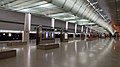 Changi Airport's platforms
 One of Tanjong Katong's platforms
 One of Raffles Place's entrances
 One of Buangkok's entrances
 One of Hume's entrances
 Chinese Garden's concourse
 Marymount's concourse
 Bedok Reservoir's concourse
 Simei's roof
 Bukit Batok's roof
 Canberra's roof
 A linkway in Dhoby Ghaut
 A linkway in Marina Bay
 A linkway in Orchard


_Tanjong_Katong_MRT_Station_Platform_B_2024-06-23_-_3.jpg)


_Hume_MRT_Station_Exits_1_&_2_2025-02-28.jpg)


Non-operational
| Station name | Station code[101][g] | Line | Condition for opening | Connections | Ref | ||
|---|---|---|---|---|---|---|---|
| English | Chinese[102] | Tamil[103] | |||||
| Bukit Brown | 武吉布朗 | N/A | CC18 | Circle Line | Sufficient demand for the station | [104] | |
| Marina South | 滨海南 | மரீனா சவுத் | TE21 | Thomson–East Coast Line | In tandem with developments in Marina South | [105] | |
| Mount Pleasant | 快乐山 | மவுண்ட் பிளசண்ட் | TE10 |
In tandem with developments in Mount Pleasant | |||
| Tagore | N/A | N/A | N/A | N/A | [106] | ||
 Bukit Brown's vent shaft
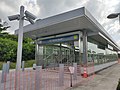 One of Marina South's entrances
 One of Mount Pleasant's entrances


Under construction
| Station name | Station code[107][g] | Line[c] | Expected date of opening[h] | Connections | Ref | ||
|---|---|---|---|---|---|---|---|
| English | Chinese[108] | Tamil[109] | |||||
| Aviation Park‡ | 航空园 | ஏவியேஷன் பார்க் | CR2 | Cross Island Line | 2030 | [54] | |
| Bahar Junction* | 峇哈路口 | N/A | JS7 | Jurong Region Line | Mid-2028 | [110] | |
| Bedok South | 勿洛南 | பிடோக் சவுத் | TE30 | Thomson–East Coast Line | Second half of 2026 | [51] | |
| Bukit Batok West | 武吉巴督西 | N/A | JE3 | Jurong Region Line | 2028 | [52] | |
| Cantonment | 广东民 | கெண்டொன்மன் | CC31 | Circle Line | Mid-2026 | [52] | |
| Choa Chu Kang West | 蔡厝港西 | N/A | JS2 | Jurong Region Line | Mid-2028 | [52] | |
| Corporation | 企业 | JS5 | |||||
| Defu | 德福 | டெஃபு | CR7 | Cross Island Line | 2030 | [54] | |
| Elias | 伊莱雅 | இலியாஸ் | CP2 | Cross Island Line Punggol Extension | 2032 | [56] | |
| Enterprise | 事业 | N/A | JS9 | Jurong Region Line | 2029 | [52] | |
| Founders' Memorial | 建国先贤纪念园 | தேச நிறுவனர்கள் | TE22A | Thomson–East Coast Line | End of 2028 | [53] | |
| Gek Poh | 玉宝 | N/A | JW1 | Jurong Region Line | Mid-2028 | [52] | |
| Hong Kah | 丰加 | JS4 | |||||
| Jurong Hill | 裕廊山 | JS11 | 2029 | ||||
| Jurong Lake District | 裕廊湖区 | ஜூரோங் லேக் வட்டாரம் | CR19 | Cross Island Line | 2032 | [55] | |
| Jurong Pier^ | 裕廊渡头 | ஜூரோங் பியர் | JS12 CR21 | Jurong Region Line Cross Island Line (under planning) |
2029 | [111] | |
| Jurong Town Hall | 裕廊镇大会堂 | N/A | JE6 | Jurong Region Line | 2028 | [52] | |
| Jurong West | 裕廊西 | JS6 | Mid-2028 | ||||
| Keppel | 吉宝 | கெப்பல் | CC30 | Circle Line | Mid-2026 | [52] | |
| Loyang | 罗央 | லோயாங் | CR3 | Cross Island Line | 2030 | [54] | |
| Maju | 马裕 | மாஜு | CR16 | 2032 | [55] | ||
| Nanyang Crescent | 南洋弯 | N/A | JW4 | Jurong Region Line | 2029 | [52] | |
| Nanyang Gateway | 南洋门 | JW3 | |||||
| Pandan Reservoir‡ | 班丹蓄水池 | JE7 | 2028 | ||||
| Pasir Ris East | 巴西立东 | பாசிர் ரிஸ் ஈஸ்ட் | CR4 | Cross Island Line | 2030 | [54] | |
| Peng Kang Hill‡ | 秉光山 | N/A | JW5 | Jurong Region Line | 2029 | [52] | |
| Prince Edward Road | 爱德华太子路 | பிரின்ஸ் எட்வர்ட் ரோடு | CC32 | Circle Line | Mid-2026 | [52] | |
| Riviera | 里维拉 | ரிவியாரா | CP3 – PE4 | Cross Island Line Punggol Extension | 2032 | [56] | |
| Serangoon North | 实龙岗北 | சிராங்கூன் நார்த் | CR9 | Cross Island Line | 2030 | [54] | |
| Sungei Bedok^ | 双溪勿洛 | சுங்கை பிடோக் | DT37 TE31 | Downtown Line Thomson–East Coast Line |
Second half of 2026 | [51] | |
| Tampines North | 淡滨尼北 | தெம்பினிஸ் நார்த் | CR6 | Cross Island Line | 2030 | [54] | |
| Tavistock | 达维士笃 | தெவிஸ்தொக் | CR10 | ||||
| Tawas | 大华士 | N/A | JW2 | Jurong Region Line | Mid-2028 | [52] | |
| Teck Ghee | 德义 | டெக் கீ | CR12 | Cross Island Line | 2030 | [54] | |
| Tengah | 登加 | N/A | JS3 | Jurong Region Line | Mid-2028 | [52] | |
| Tengah Park | 登加公园 | JE2 | 2028 | ||||
| Tengah Plantation | 登加种植 | JE1 | |||||
| Toh Guan | 卓源 | JE4 | |||||
| Tukang | 都康 | JS10 | 2029 | ||||
| Turf City | 马城 | டர்ஃப் சிட்டி | CR14 | Cross Island Line | 2032 | [55] | |
| West Coast^ | 西海岸 | வெஸ்ட் கோஸ்ட் | CR18 | Jurong Region Line (planned) Cross Island Line |
[112] | ||
| Xilin | 锡林 | ஸீலின் | DT36 | Downtown Line | Second half of 2026 | [51] | |
 Keppel's construction site
 Sungei Bedok's construction site
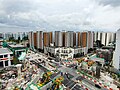 Bahar Junction's construction site
 Jurong Town Hall's construction site
 Nanyang Crescent's construction site
 Defu's construction site
 Maju's construction site
 Riviera's construction site


Planned
| Station name | Station code[113][g] | Line | Expected date of opening[h] | Connections | Ref | ||
|---|---|---|---|---|---|---|---|
| English | Chinese[114] | Tamil[115] | |||||
| Brickland | 红砖 | பிரிக்லேன்ட் | NS3A | North–South Line | 2034 | [57] | |
| Changi Terminal 5^ | 樟宜第五搭客大厦 | சாங்கி ஐந்தாம் முனையம் | TE32 CR1 | Thomson–East Coast Line Cross Island Line |
Mid-2030s | [58] | |
| DE1 † | N/A | N/A | DE1 | Downtown Line | 2035 | [59] | |
| JS2A † | JS2A | Jurong Region Line | Mid-2030s | [52] | |||
| Sungei Kadut‡ | NS6 DE2 | North–South Line Downtown Line |
2035 | [116] | |||
 Brickland's site
 Changi Terminal 5's site
 DE1's site
 JS2A's site
 Sungei Kadut's site


